


Construction Drone Services in Norfolk, NE | Aerial Site Maps, Volumes & Erosion Monitoring

Construction drone services in Norfolk, NE, follow a job from the first stake to the final walk-through. DroneX Services captures the existing ground, tracks each phase, and records the finished site, so the file you hand over at closeout matches the work actually built. Bare-ground flights set the baseline. Along the way you receive maps, surface models, stockpile volumes, and dated photos that anyone can open: a superintendent in the trailer, an owner in another town, and an inspector on site. Tell us the acreage, the phase, and who needs the data. We will build a flight schedule around your milestones and keep it flexible when rain moves the pour.

drone technology for construction
Get a free Estimate

WHAT CAN WE DO FOR YOU?

Check Out Our Services in Norfolk, NE

Jobs rarely stay in one lane, and neither does our work. A builder who needs site maps today may need a roof check in spring, and a client who owns farm ground may want drainage maps before a new shop goes up. Rough sketches and old plans are fine as a starting point. The five services below show where drones fit. Read the one that fits your project now, then keep the others in mind for later phases. If you are juggling several needs at once, say so and we will propose an order that makes sense.

Agricultural Drone Services

Utility, road, and pipeline projects often cross active cropland. We map the affected acres before work starts and again after restoration, so landowners, contractors, and agencies can settle crop-damage questions with dated aerial images. The same aircraft and crew that spray and scout fields for growers around agricultural drone services in Norfolk handle these flights, so the maps speak the language farmers and agronomists use. Elevation layers also show settled trench lines.


Drone Sales

Excavation and paving firms looking into Drone Sales often want their own aircraft for stockpile counts and quantity checks. We explain what accuracy to expect without RTK, what changes with it, and how to check results against a known elevation. Software licenses, laptops, and training time belong in the real price, so we include them. If hiring a survey flight costs less this year, we say so. Some firms hire a few flights first and buy later, once the numbers add up.

.

Drone Inspection Services in Omaha, NE

Drone Inspections

Property drone inspection services in Norfolk help buyers, lenders, and managers see a building’s condition before closing, while industrial drone inspection services in Norfolk cover silos, tanks, stacks, and plant roofs. Both end with sorted images and plain notes. Contractors also use these flights at punch-list time, since a drone reaches parapets, flashing, and high glazing quickly. We tag images by wall and level, so each item is easy to find.


Construction Drone Services

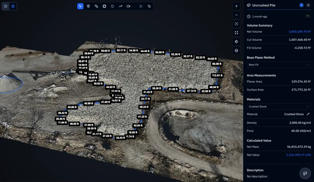
Construction drone services in Norfolk starts before mobilization. One flight records existing grade, trees, ditches, and structures, and a second flight after clearing records the changes. Cut-and-fill numbers and haul road layouts and drainage paths come from the same data. Later flights track footings, slabs, and steel, and a final flight documents as-built conditions. Stockpile volumes follow from those flights, with dates and weather logged.

Search and Rescue

Storms and floods can leave a job site unsafe before anyone can walk it. A Search and Rescue drone can look over trenches, cranes, fencing, and standing water without sending a person in, and thermal can help find someone who needs help after dark. We take direction from the responders in charge and share images in the format they ask for. Owners and adjusters also want a record before cleanup starts, so we photograph damage from several angles with dates attached.


aerial inspections

LEARN MORE ABOUT US

Who are we?

A drone map answers many questions on a job site, and a few belong to others. Site surveying in Norfolk, in the legal sense of boundaries and legal descriptions, is the work of a licensed Nebraska land surveyor. DroneX Services supplies the aerial data that surveyors, engineers, and estimators use for earthwork, grading checks, and progress records. We speak their language: datum, benchmark, tolerance, and control. Our pilots log each flight, keep raw files, and share results in formats you use. If a drone cannot meet a tolerance, we say so before you hire us. Send us your specifications, and we will confirm what the aircraft can realistically deliver.

Why Choose DroneX Services

Job-site data is only useful when it arrives on time and matches the last flight. DroneX Services keeps flight settings, control points, and file names consistent from the first visit to the last, so week 12 lines up with week 2. Between visits we log weather, ground conditions, and anything that changed on site. A missed week leaves a gap nobody can fill in later, so we hold backup days on the calendar. Here are four things to look for when you compare construction drone providers around Norfolk.

Reasons to Trust

Accuracy is stated early. We tell you what ground control is used and what error range to expect, so your engineers know how far to trust every layer.

Your Best Choice

One flight can feed several teams: grading checks for the superintendent, volumes for the estimator, photos for the owners and records for the lender.

Right Choice for You

A small infill lot or a big industrial pad, we scale flights and data to the project. Short jobs and single flights are fine, like one pre-pour check.

Professional

We check airspace, wind and site rules first, wear high-vis gear, check in with the foreman and stay clear of moving equipment and lifting operations.

Google Review

Write a Review

Webb Wallace
★★★★★
“Exceptional service! The drone team provided detailed aerial data that made farm management so much easier. Highly recommend their expertise.”
Renae Stringer
★★★★★
“Professional and reliable! Their inspection drones saved us time and gave accurate results we could trust.”
Erik Young
★★★★★
“Outstanding experience from start to finish. The team’s knowledge and technology exceeded our expectations and delivered great results.”

Top Rated Construction Drone Services in Norfolk, NE

Construction drone services in Norfolk earn their keep in wet springs. Sites over an acre usually need erosion and sediment controls, and inspectors expect to see silt fence and inlet protection holding, along with stabilized entrances. A drone flight after a heavy spring rain shows failures across the whole site within minutes, with dated photos to back up your inspection log. The same data flags ponding, rutted haul roads, and soft subgrade before the concrete truck arrives. Winter brings a few other checks: drifted snow on stockpiles, ice at entrances, and frozen haul roads that thaw into mud. Frost, mud, and wind change what we can fly, and we adjust the schedule rather than force a flight.


Check Out Our Gallery

Proudly Serving Norfolk, NE & Nearby Agricultural Communities

Our reach covers Norfolk and the building activity around it: industrial pads near the highways, subdivisions on the edge of town, school and church additions, and livestock buildings on the county roads. We also work in Madison, Battle Creek, Pierce, Stanton, and Wayne. Travel is part of rural construction, so we plan flights around road conditions, load limits, and weather. Seasonal weight limits on county roads can slow equipment, and they can slow us too, so we schedule trips with that in mind. Larger projects farther out are welcome too. Contact us with the site location and approximate size, and we will tell you how soon we can get there.

Call Us Now

Planning a bid or already on site? DroneX Services picks up at [phone number]. Share the address, acreage and phase. Send a site plan, CAD files, or bid set if you have one, and we will lay our maps over it. Tell us which dates matter, such as pay applications, stormwater inspections, city inspections, or lender draws. We will respond with a flight plan, a price, and a schedule that stays flexible if weather shifts. All questions are welcome at any stage, including before you win the bid. A small excavation crew, a builder’s office or a county department can keep the first call short: location, size, and the question you want the drone to answer.

Frequently Asked Questions

How are drones used on construction projects in Norfolk, NE?

Drones record existing ground, track grading and structures, measure stockpiles, and document finished work. In Norfolk, they help show where water collects on flat valley sites and how erosion controls hold up after storms, using dated aerial images.

Yes. Flights over the same boundaries at the same settings create maps that overlay cleanly, so new slabs, fill and haul roads stand out clearly. Most active sites fly weekly or every other week, with extra flights after storms or before major pours.

With good control points and RTK, volumes are typically accurate enough to support pay requests and stockpile counts. Without control, expect more error. We state the likely range up front and suggest ground checks for very large or high-value piles.

Orthomosaic maps, surface and terrain models, contour lines, volume reports, 3D point clouds, progress photos, short videos and annotated images. We also provide files that CAD, GIS, and estimating software can open, if you tell us which ones you use.

Can drone mapping help document erosion control and stormwater measures?

Yes. Aerial images show silt fence, inlet protection, stabilized entrances, and bare slopes across the whole site, with dates attached. They support inspection logs and flag issues, but they do not replace the on-site inspections your permit requires.

Comparing a new surface model with design elevations shows low spots, high spots, and places where water will pond. Fixing a grade error before forms or rebar go in costs far less than correcting it after the pour. A follow-up flight confirms the fix.

Most active sites need a flight every one to two weeks, more often during mass grading or when storms hit. Slow phases can stretch to monthly. We build the schedule around your milestones, pay dates and inspection dates, then adjust it as work moves.

Yes. Dated aerial photos and before-and-after maps help people who cannot visit often follow progress. We can package a short monthly set for owners and lenders alike and keep a full archive for disputes, project closeout, and future maintenance work.

CONTACT US

You Can Contact Us Any Time