


Construction Drone Services in Lexington, NE | Site Mapping & Progress Tracking by DroneX Services

Construction drone services in Lexington, NE give a job site something it rarely has: one clear picture of everything at once. DroneX Services flies the lot before the first scraper moves, then returns on a schedule to record progress. Crews keep working. Superintendents see grade changes. Owners see what they are paying for. Along the way we produce maps, 3D models, stockpile volumes and straight-down photos that line up week after week, so you can compare Tuesday’s dirt against last month’s. Tell us the size of the site, the phase and the decisions coming up. We will suggest a flight schedule that matches your build, not a generic calendar.

construction drone services
Get a free Estimate

WHAT CAN WE DO FOR YOU?

Check Out Our Services in Lexington, NE

Think of this page as one corner of what we offer. Besides site work, we spray and scout crops, sell drone equipment, inspect buildings and structures, and assist in searches. Many customers use two or three of these over time: a builder who also owns farmland, a contractor who needs a roof check after a hailstorm and a map before spring. Pick the card below that fits your current need right now. If nothing matches, tell us what you are trying to accomplish and we will work backwards from there.

Agricultural Drone Services

Many builders in this area also farm or manage rural land. Our Agricultural Drone Services handle spray flights, crop mapping and scouting for that side of the business. Drainage maps made for a field also help with site planning, since a low spot that floods a bean field can flood a building pad, too. The same mapping skills transfer between a pivot corner and a parking lot. After spring rains, those maps show which acres drain last and which spots need fill before pouring.


Drone Sales

Contractors with steady survey needs sometimes decide to bring drone sales work in-house. We help you weigh aircraft, RTK gear, mapping software and the time your crew will need to learn them. Often a mix works best: you own a small drone for quick progress shots and hire us for monthly mapping flights. We will tell you honestly which approach saves money for your workload. Training time is a real cost, and we count it in the comparison from the start.

Drone Inspection Services in Omaha, NE

Drone Inspections

Property drone inspection services in Lexington cover roofs, facades, parking structures and rooftop equipment on existing buildings, which is useful before a purchase or a renovation. Industrial drone inspection services in Lexington go further, covering stacks, tanks, conveyors and large process roofs that are awkward to reach. Both produce sorted images with notes, so decisions rest on pictures instead of guesses. Reports stay short and clear.

Construction Drone Services

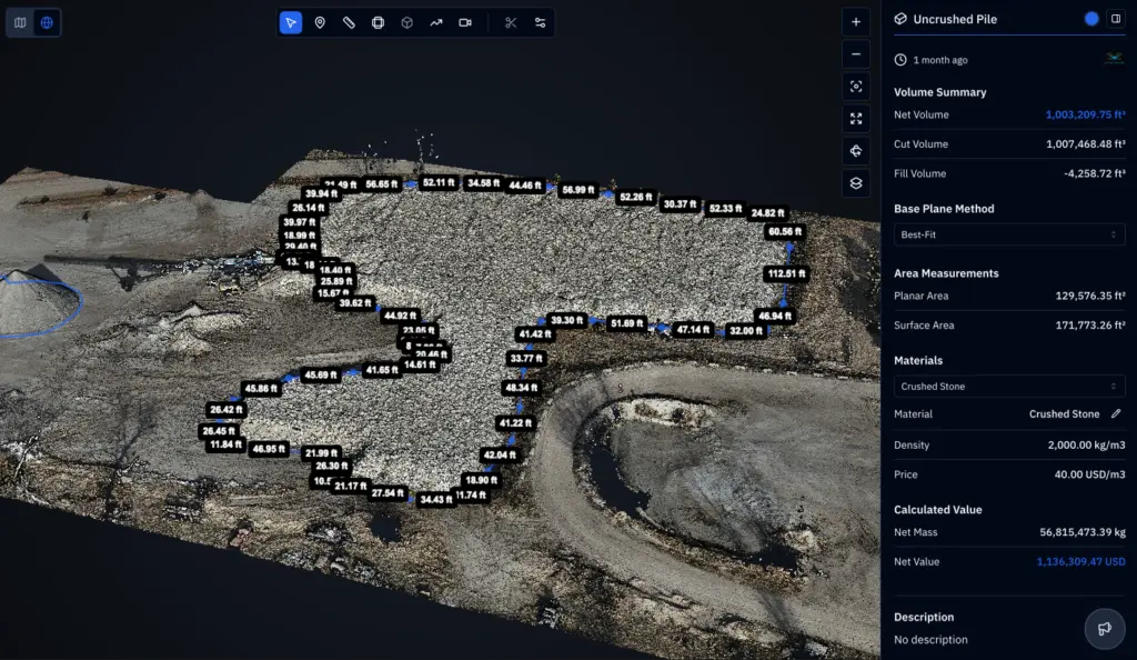
Our core offering covers construction drone services topography, earthwork volumes, progress mapping and as-built documentation. Each flight yields an orthomosaic map and a surface model you can measure on screen. Cut-and-fill numbers, stockpile volumes and slope checks come straight from that data, so you spend less time walking the site with a tape. Time-stamped images protect everyone when schedules slip. Pay applications get easier to back up with data.

Search and Rescue

Missing-person and missing-livestock calls arrive at odd hours, and open country around Lexington can swallow a search team. Thermal and zoom cameras let responders cover that ground quickly. We fly grid patterns, report what we see and follow the incident commander’s directions. The discipline that keeps a mapping flight accurate keeps a search and rescue flight useful. We also pass along GPS coordinates and screenshots so crews know exactly where to walk.

drone inspections

LEARN MORE ABOUT US

Who are we?

A Nebraska drone operator, DroneX Services spends as much time with survey files as it does with propellers. Construction customers need numbers they can use: volumes, elevations, distances and dates. So we deliver data in formats that designers and estimators already work with, and we explain how to read it. Our pilots also fly farm, inspection, and search missions, which keeps their eyes sharp for details like erosion lines, standing water, and unstable ground. Bring us a site plan, a question, or a problem that has stalled your build schedule. We will start there. We will say plainly where a drone map stops being the right tool for the task.


Why Choose DroneX Services

Job sites change almost daily. A mapping flight that arrives two weeks late only records yesterday’s news. DroneX Services builds a schedule around your milestones: clearing, grading, utilities, foundations, and framing. Between flights, we keep notes so each map stays comparable with the last. Rain, frozen ground, and upcoming inspections change what a map should show, so we ask about them up front. Below are four things that matter when choosing a drone provider for a build in or near Lexington.

Reasons to Trust

Maps are tied to ground control points when accuracy matters, and we explain what each data layer can and cannot support. Expect a stated error range.

Your Best Choice

Repeat flights reuse the same boundaries and altitudes, so Week 6 lines up cleanly with Week 2 when you compare them. Fill and cuts stand out quickly.

Right Choice for You

From a single pad to a multi-acre development, we match the flight frequency and deliverables to the job and your budget. Small jobs are welcome here.


Professional

We coordinate with site supervisors on timing, safety zones and equipment movement, so flights never slow down the crew. We bring our own safety gear.

Google Review

Write a Review

Webb Wallace
★★★★★
“Exceptional service! The drone team provided detailed aerial data that made farm management so much easier. Highly recommend their expertise.”
Renae Stringer
★★★★★
“Professional and reliable! Their inspection drones saved us time and gave accurate results we could trust.”
Erik Young
★★★★★
“Outstanding experience from start to finish. The team’s knowledge and technology exceeded our expectations and delivered great results.”

Top Rated Construction Drone Services in Lexington, NE

Construction site aerial mapping in Lexington has its own wrinkles. The Platte Valley’s high water table means drainage questions come up early, and a map made after a wet week shows where water sits. Winter frost reaches about three feet down, so footing and utility depths matter. Our maps show elevation contours, ponding areas, and haul road conditions. Stockpile volumes for gravel, topsoil, and aggregate come from that same flight, which helps with pay applications. Flat valley ground hides small grade errors until heavy rain arrives. Site surveying in Lexington often starts with this kind of data, although boundaries and legal descriptions still belong to a licensed Nebraska land surveyor.

Check Out Our Gallery

Proudly Serving Lexington, NE & Nearby Agricultural Communities

Construction crews working around Lexington know the pattern: a subdivision here, a warehouse near the interstate, and a livestock facility out past the edge of town. We provide construction drone services in Lexington and fly sites like these across Dawson County and nearby Cozad, Overton, Elm Creek, Gothenburg, and Kearney. Rural builds bring their own challenges, such as long gravel approaches, no cell signal, and strong wind on open sites. We plan around those realities. Frozen ground and soft shoulders change when we can reach a site, so we confirm access first. Not sure if your project is in range? Call, describe the site, and we will check.

drone technology for construction

Call Us Now

Starting a project or stuck in the middle of one? Dial [phone number] for DroneX Services and tell us where the site is, how big it is, and which phase you are in. If you have a site plan, a CAD file or a bid set, we can use it to build a flight plan. We will also ask about deadlines, such as pay application dates or inspections, so the data arrives when it can help. If the site has a gate code, a locked entrance or soft ground, tell us. Weather delays do happen, and we would rather reschedule than fly a bad day and give you bad data. After that, you get a quote and a proposed schedule. Early calls give us room to catch the first grading pass.Call us for a free quote; we are available for on-location missions across Lexington and the surrounding areas.

Frequently Asked Questions

How are drones used for construction projects in Lexington, NE?

Drones map whole sites before work starts, track weekly progress, measure stockpiles, check grading, and inspect roofs or structures once complete. Around Lexington, they also help with drainage planning on flat valley ground where water moves slowly.

Yes. Repeat flights over fixed boundaries produce maps that line up, so you can compare them and see what changed. Weekly or biweekly flights fit most builds, and we can add flights after storms or major pours. Slow changes look obvious side by side.

They can. The drone records the pile from every angle, software builds a 3D surface, and then compares it with the ground beneath. Results are usually reliable enough for pay applications and inventory checks, though large piles deserve ground checks.

Orthomosaic maps, elevation models, contour lines, stockpile volumes, 3D models, progress photos, video walkthroughs, and thermal imagery. We’ll suggest which ones fit your project so you never pay for data you won’t use. Files open in common formats.

How can drone mapping help construction companies manage their job sites?

It shows the whole site at once, which helps with logistics, traffic flow, lay-down areas, and safety zones. Managers spot drainage problems, off-plan grading, and equipment congestion earlier, and they can share one image with the whole project team.

Yes. Comparing surface models with design grades highlights areas that are too high or too low. Ponding, erosion rills and washed-out haul roads also show up quickly. Early notice usually means smaller fixes. Fixes can be verified on the next flight.

Weekly or biweekly suits most active builds. Earthwork phases may need more frequent flights, while slower phases can stretch longer. We will propose a schedule around your milestones and adjust it as the job evolves. Billing dates also help us plan.

Absolutely. Dated aerial photos and side-by-side maps make progress easy to understand for people who cannot visit often. Owners can send a short monthly set to lenders and partners. We can format it for that. It also builds a clean record for later.

CONTACT US

You Can Contact Us Any Time